
How to get here Wiseman History Surroundings
Features


Photos
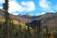
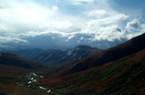
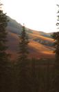
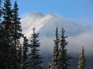
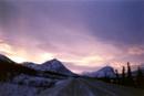
by Scott & Heidi Schoppenhorst
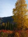
(left to
right) Fields
of fireweed in burn area N of Yukon River, Finger Rock (Feb), Middle Fork of
the Koyukuk River at turnoff from Dalton Hwy,
East
view of mountains across from Wiseman, Watch out for other travelers! Snow
encases black spruce along the Dalton in winter.
How to get here:
Wiseman is located 272 miles (435 km) north of Fairbanks, which
is the nearest city, and 13 miles north of Coldfoot, which is the nearest
service area with food & fuel available.
The turnoff to Wiseman Village is located at Milepost 188.5 on the
Dalton Highway, just over the Middle Fork of the Koyukuk River bridge, and it
is 3 miles (4.8 km) into the village.
Driving from Fairbanks
is the most common means of travel to Wiseman. To reach the Dalton Highway from
Fairbanks, you will need to get on the Elliott Highway, which will link up with
the Dalton 84 miles (134 km) north. The highway is paved from Fairbanks to Gold
Creek, which is approx 10 miles (16 km) north of Wiseman. However, there are
intermittent stretches of gravel road for approx. 78 miles (125 km) to the
south of Coldfoot. Dalton is gravel north of Gold Creek, with intermittent
paved stretches, and well maintained.
There are also
commercial flying services that fly
into Coldfoot from Fairbanks, Coldfoot Camp offers van service to Wiseman (check
with them prior for schedule & fees), and Commercial van service from
Fairbanks is available through Fairbanks based companies, as well as rental car
companies. Please write or call for more information on travel services &
visit our links page.
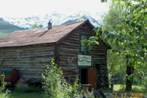
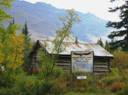
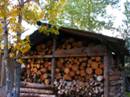
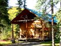
Photos by Scott & Heidi Schoppenhorst
(Left) Wiseman
Trading Co. was established in 1910. Although closed for many years, it is now
open seasonally offering T-shirts and limited gifts for sale, and provides the
opportunity for viewing many antiques from the early days. (Center) Wiseman
Post Office, closed in 1956, was first opened in Coldfoot 1912, and later moved
to Wiseman. Today mail is received once again through the contract Post Office
in Coldfoot. (Right) Historic cabin near Boreal Lodge, Kahalabuk
Memorial Chapel (always open!), full woodshed, reflected sunlight on
mid-December sky.
Wiseman History:
Wiseman was established in 1907 to
accommodate the needs of the growing number of gold miners and prospectors
drawn to the placer rich creeks of this Koyukuk valley. Primarily a trading
community, Wiseman once supported a population of about 250 residents, and
maintained a post office, general store, roadhouse, Pioneer Hall, telegraph
office, and school. This is one of the few white founded communities located
north of the Yukon River, and is the furthest north “gold rush” settlement in
the Brooks Range still in existence today. The Koyukuk valley has also been
rated 6th in gold production for the State.
The intrigue of such a remote community, surrounded by the Brooks Range
wilderness attracted early visitors as well, such as Bob Marshall in 1929, the
first “tourist” to the Brooks Range. He ended up spending about 13 months here.
Published accounts of his experiences in this area are the books, Arctic
Village, and Alaska Wilderness. The approx. 8.5 million acre “Gates
of the Arctic National Park and Preserve”, borders to the west of the village
of Wiseman. The name is derived from an account of Bob Marshall’s journey west
into the North Fork of the Koyukuk River Valley, and refers to the mountains of
Boreal and Frigid Crags.
Wiseman’s population has fluctuated
throughout the years, but the town has never been abandoned. Though there are
still many gold miners and prospectors in the area during the summer months,
the adventure of an arctic subsistence lifestyle has intrigued and held others
in this remote community year-round. The
land in Wiseman is privately owned. The owners have restored and continue to
use the original log cabins from the early days.
Services are limited; the Wiseman Trading
Co. is open seasonally, and businesses & services open year round are the Kalhabuk Memorial Chapel, Boreal Lodge, B&B, and local
residents offering furs, and jewelry. Boreal Lodging offers some local gifts
and limited groceries/essentials in the office gift shop open primarily May
through September, and will open on request during winter months. Heidi
Schoppenhorst is a contract vendor for fishing & hunting licenses, and
licenses / tags can be purchased from her at the Boreal Lodge. Currently there
are no restaurants or gas stations in Wiseman, visitors have the option of
bringing their own food from Fairbanks (recommended - Boreal Lodge offers full
cooking facilities), or Coldfoot Camp serves meals and has fuel for sale. There
are no other stores in Wiseman or Coldfoot, please plan ahead for any
anticipated supplies needed before leaving Fairbanks.
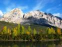

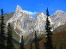
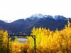
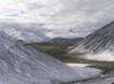
Photos by Heidi Schoppenhorst
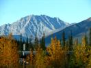
(Left to right) Sukakpak Mt., located at MP
204, viewed from the north with pipeline in foreground, autumn color graces the
Brooks Range – viewed from atop Chandalar Shelf,
color along the Dietrich River, view of Poss Mt.
reflection, about 8 miles north of Wiseman, midnight sun highlights clouds over
Emma Dome between Coldfoot/Wiseman.
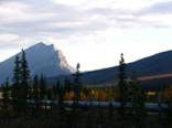
Surroundings:
The Brooks
Mountain Range runs east to west and stretches nearly 720 miles across northern
Alaska. Wiseman is located within the heart of this rugged & beautiful
Range, approximately 75 miles north of the Arctic Circle, and approximately 50 miles
south of the Continental Divide, (halfway between Fairbanks & oilfields of
Prudhoe Bay in the Arctic Ocean). Wilderness stretches either side of the
Dalton Highway, and is home to grizzly & black bears, Dall
sheep, moose, caribou, Musk Ox, wolves, and a variety of smaller furbearers.
Migratory birds travel from around the world each spring to reach the arctic in
search of nesting grounds. Over 180 species of migratory birds have been
counted within the Brooks Range, and on the rolling arctic tundra of the North
Slope & Coastal Plain.
Wiseman is
surrounded by public lands; located within the BLM utility corridor, the
Trans-Alaska Pipeline runs through this Koyukuk River valley across from
Wiseman. To the west, Gates of the Arctic National Park & Preserve, the
second largest Park in our system (and all wilderness) parallels the valley
directly behind Wiseman. To the northeast, the furthest western border of the
Arctic National Wildlife Refuge (largest Wildlife Refuge in the refuge system)
comes very close to the Dalton Hwy Just over the Continental Divide across from
Galbraith Lake.
To find out more
about these public lands, please visit the links below:
![]() Gates of the Arctic National Park & Preserve
Gates of the Arctic National Park & Preserve
![]() Arctic National Wildlife Refuge
Arctic National Wildlife Refuge
![]() Visit our Wildlife page to learn
more about what you may see & when to see it!
Visit our Wildlife page to learn
more about what you may see & when to see it!
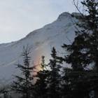
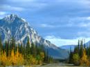
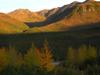
Photos by Scott & Heidi Schoppenhorst
(Left
to right) pipeline & fall color north of Wiseman, Aspen leaves turning
color on the Nolan Rd (2 miles NW of Wiseman), Rainbow Gulch – about 5 miles
north of Wiseman, Pipeline & rugged
mountains north of Wiseman, another pretty scene from the Nolan Road (west of Wiseman).
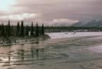
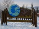
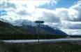
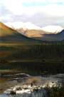
Photos by Scott, Chris, Heidi Schoppenhorst
(Left to Right) Middle Fork of the Koyukuk River, Arctic Circle
sign at pull-off 74 miles south of Wiseman, Dillon Mt viewed from Dalton in
August., fresh snow on mountains viewed behind Lodge (Oct), Snowdon
Mt. about 30 miles N. of Wiseman.
Seasons are very dramatic
here in the arctic!


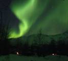
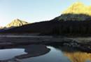
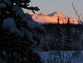
Photos by Scott, Chris, Heidi Schoppenhorst
(Left to Right) Alpenglow, Wiseman Crk.
Canyon overflow ice, snow peaks, pink Nov. sky, Aurora,-35 F, Jan 1st,07, fresh
snow behind Wiseman, Dalton overlooking Yukon River (south)
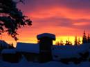
Winter:
The most quiet & peaceful time of the year ~ also the
longest season in the arctic. The ground, rivers, and creeks begin to freeze up
by late September, and generally we have snow that stays by mid-October.
Snowfall accumulations can range between 2 – 7 feet during a winter, but on
average we have about 2 – 3 feet on the ground. Temperatures will range
anywhere from 30 degrees F above zero, to –65 degrees F below zero, and weather
changes quickly since we are in the mountains & close to the Continental
Divide. The sun dips below the southern horizon around December 5th,
not to return until approx. Jan.8th – during this time, there are
still a few hours of daylight, but not sunlight. The advantage of all the
darkness is more time to view the Aurora Borealis! - Which is spectacular from
this location and can be viewed most every clear night, offering great
photography opportunities. February & March are excellent months to
experience winter in the arctic – long sunny days of March provide enough
warmth to get out & enjoy the country, whether driving up the road to check
out the scenery, cross country skiing, snow shoeing, or just hiking around. Dog
sled rides & trips are offered nearby from a local Coldfoot resident.


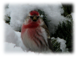
Photos by Chris, Heidi Schoppenhorst
(Left to Right) Snow buntings arrival in April marks spring has
arrived! Koyukuk River ice break up/high water near Wiseman, Spring crocus,
looking toward Wiseman from across river, Bluebells by Lodge,
ewe & lamb near Atigun Pass, night
light on Kahalabuk Mt in June
Spring:
Ice in the rivers & creeks start to melt & break up
between mid-April and mid-May. Along with the appearance of all this water, the
migratory birds begin to arrive by the hundreds, stopping off throughout this
valley on their journey north to the wetlands of the North Slope tundra. Spring
is also the time of year to view more wildlife in the Wiseman area and along
the Dalton, as this valley tends to melt first close to the road & offers a
good place for wild critters to have their young; moose, Dall
sheep in Atigun Pass, caribou & Musk Oxen on the
north slope are all calving this time of year. Grizzly & black bears,
wolves & fox all tend to come near to the road as well, in search of an
easy meal. Early spring, during breakup, is a poor time for hiking or
attempting any type of float trip on the rivers, but does offer excellent
wildlife viewing opportunity, and generally fewer visitors to the area.

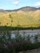


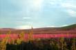
Photos by Chris, Heidi Schoppenhorst
(Left to Right) Delphiniums near spruce gate, wild sweet pea
blooms along Wiseman Road near Koyukuk River, rare white fireweed, gold
panning, Wild Rose, Tundra Rose, double rainbow over Boreal Lodging gate,
Midnight sun over Brooks Range w/fireweed on Solstice.
Summer:
By mid-June the ground has dried up, trees are leafing out, and the wildflowers are in full bloom. June
offers 24 hours of sunlight, only dipping behind the mountain peaks at “night”, but never actually setting – this
will peak on Summer Solstice, June 21st. June generally offers clear
skies & the best of summer weather, temperatures will occasionally reach
into the mid 70’s & 80’s during June & July, but tend to average in the
60’s. Hiking, photography, gold panning,
river floating, flight seeing, & sport fishing for grayling in the streams
along the Dalton are all possible pastimes in the area. The Arctic Interagency
Visitor Center in Coldfoot is also open June – August, and offers information
on all of the above activities, nightly slide presentations, and an educational
book / gift shop.
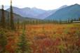


Photos by Chris, Heidi Schoppenhorst
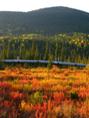
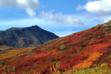
(Left to Right) Fall color 10 miles N of Wiseman, Chandalar shelf in August, ripe cranberries w/red dwarf
birch, yellow cottonwood leaves in Sept, august color N. of Wiseman, first snow
looking south on Atigun Pass.
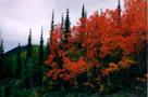
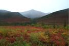
Fall:
Summer is already on its way out by the second week of August,
and by the 3rd week the tundra on the mountains & surrounding
landscape is alive with color. Wild blueberries & cranberries in the area
are ripe, and dwarf Birch, berry bushes, Cottonwoods, & Aspen present a
spectacular color show after the first frost. Wildlife again becomes more
visible as the leaves fall, and grizzlies are commonly viewed from the highway
as they search for berries & other snacks before their long winter’s sleep.
Migratory birds again travel through this valley on their long journey back
south. Fall is prime time for hiking & photography – cooler weather also means
less mosquitoes. Rivers do not tend to start freezing again until late
September, so floating, gold panning, & fishing are all still possible
activities.


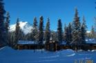
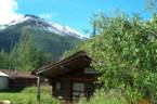
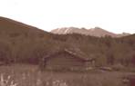
Photos by Scott & Heidi Schoppenhorst
(Left to Right) Scenery on Dalton in early January, Boreal Cabin,
Fireweed, Fall colors north of Wiseman late August, Lodge in winter, last sun
on Poss Mt viewed behind Lodge (Dec).
Boreal Lodging offers a great staging location for
any of the above activities. Whether you are just looking for a place to
overnight on your way to the Arctic Ocean, or would like to spend a few days or
a week to enjoy the wilderness & history of this area. We are off the
highway, and provide comfortable accommodations with the most reasonable rates
in the area. We will be happy to answer any questions you may have to help plan
your trip to the arctic, and will offer honest advise & suggestions
regarding any activity you may be interested in. Hope to see you soon!
CONTACT:
Phone / Fax: 907.678.4566
e-mail: boreallodge@gmail.com
Last revised: March 2020
Copyright 1999-2020 Boreal Lodging, all rights reserved